
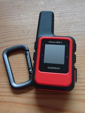
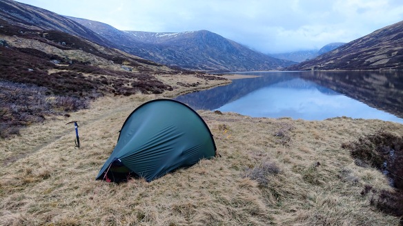
The Garmin inReach Mini 2 is a satellite facilitated tracking and text message communication device. It is small and light and designed to be used in combination with a Bluetooth enabled smartphone to act as remote keyboard and larger viewing screen. As the name suggests it is the second incarnation of this device. I bought one of these earlier in the year to give my family peace of mind when I was on an eight day solo wild walk across the Cairngorms.
Executive Summary
I found the unit easy to use and my family found messaging me and following my location using the tracking page straight forwards when I was in the field. The battery life was excellent, it would have lasted 12 days between charges using the configuration I chose. The reassurance of having a ‘Daddy Tracker’ was highly appreciated by the family and I benefited from getting messages and MWIS summaries sent from home. It gets a thumbs up from me.
What does it do / why might you want one?
By linking to both the US GPS, international GNSS and Iridium satellite networks it can pinpoint your location anywhere in the world where you have sight of the sky. Then by using its connection to the Iridium network (which is what powers satellite phones) it can broadcast your position back to your support team / loved ones via a Garmin hosted webpage. It does this at a frequency anywhere from once every two hours to as often every two minutes.
Using the Iridium network it allows the transmission and receipt of 160 character text messages. These can be sent to a mobile phone, received as an SMS message, or sent to an email account. A link within outgoing messages allows recipients (e.g. home base) to reply to the inReach via a web based messaging portal or via SMS to a dedicated pseudo mobile phone account at Garmin.
Finally the unit has an SOS button which will transmit an emergency call and your location to the local emergency services and also your chosen two primary contacts. Thankfully I’ve not tested this, but once in contact with the emergency services you can share text messages to fill them in with your status, nature of your emergency/injury etc.
I got one so that my family could be assured that I was OK and we could keep in touch with each other for the long periods I was without mobile phone network coverage (in my case for 5 ½ of the 8 days of my trip). I was walking alone.
How easy is it to use?
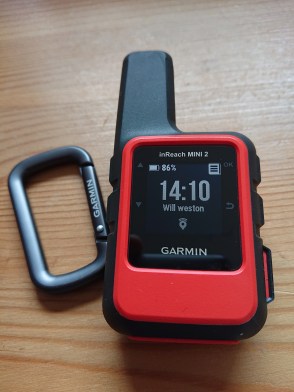 After a couple of short test walks I was able to consistently and easily use the unit. Whilst it can be used on it’s own, if you want to send bespoke rather than just preset messages this is MUCH easier when you link it (via Bluetooth) to your phone. The unit itself has only four buttons, so typing on it would be a very slow process. However, you can read even long messages on the unit itself with ease. The screen looks like that on a Kindle. Linking to the dedicated app on your phone is quick and easy. Reviews I read ahead of buying it all suggest that the Mini 2 user interface is much more intuitive than the original Mini 1. I have a 10 year old Garmin GPS Map and know that I can attest that the Mini 2 much easier and more intuitive vs. the older style of Garmin interface.
When I used the manual on / off tracking mode I found I could easily turn off the tracking by mistake. I never did work out what I was doing wrong. My solution was to set it to auto-tracking which meant I never accidentally turned off the tracking. This worked flawlessly.
Sometimes in deep valleys, or where there was tree cover it flagged a ‘poor satellite connection’ and asked if I would like to delay sending my message until it was guaranteed to sent without any errors. I opted for the ‘wait’ option and found that it never needed to wait more than 30 seconds before sending my message – a delay of no relevance as far as I was concerned. In the manual it suggested that messages may take up to 20 min to arrive with the end recipient (or get from them to me). On two occasions I had a back and forth text conversation with no perceivable delay.
Battery life?
There is always a difference between the optimal values quoted by manufacturers and real world performance. In the case of the Mini 2 your battery life will depend primarily on four main factors:
- The frequency you opt to send your location back to your Garmin web page
- How many messages you send / receive in the day
- Whether you leave the Bluetooth link on all the time or actuate it ‘as needed’
- Terrain / tree cover impacting satellite coverage.
In my case these factors were as follows
- My location was set to ping once every 30 minutes
- I sent around 10 messages per day and received 2-4
- I only turned on the Bluetooth when I wanted to send a bespoke message
- I was only rarely in deep narrow valleys or under trees
- I had the unit switched on for around 8 hours per day

inReach Mini 2 – clipped and strapped to my shoulder strap for good reception and easy of use
With the above settings / conditions I consistently used 8% of the battery life per day over my seven full days of use. Thus I could have got just over 12 days of use from a single charge of the internal Li ion cell. This seems excellent to me and all most people would every need. The unit is charged using a standard USB / phone charger (USB C) and thus can be topped up in the field using a power bank. The internal battery is 1250 mAh, so around 40% of a modern smart phone for comparison.
How the messaging works
The message payment model works as follows:
Preset messages
You can set three ‘preset messages’ via your Garmin Explorer web portal. These are fixed messages each sent to a (potentially different) fixed group of recipients. All and any aspects of these messages can only be altered via the web portal. Once set on the web you sync to your device either via USB or via the app on your phone / Bluetooth. You can send as many of these preset messages as you like at no extra charge. You can choose to include a location link within them.
Bespoke messages
Each message is up to 160 characters. These can be composed on the unit if you really have to and have a lot of patience (it has only four buttons) or are more readily composed on your phone then relayed via Bluetooth to the inReach and then up into the deep dark reaches of space. You can choose to include a location link with your message if you wish.
The cost of bespoke messages and location pings depends on the level of subscription you decide to pay for. Each subscription package includes some complimentary messages / pings and then you pay per message / ping after that. Since these costs will likely change with time best that you look here on the Garmin site for more information. This third party video is good too.
Both outgoing and incoming messages count towards your quota and will cost you once this quota has been exceeded. (Currently £0.50 / message).
Once you message someone, they can message you back.
Weather information
You can pay to have a weather forecast sent to you, it is multi-day forecast and can be standard or premium. I didn’t use these services so cannot comment. I arranged for Mrs W to send me a summary of the MWIS mountain forecast every other day. This service proved excellent!
Web portal configuration
This is very important as the settings on the portal will determine what your audience will see and what functions they will have available to them. You share a URL with them of the form https://share.garmin.com/xxxxxx. You can password protect the page if you wish and choose whether you want it to be possible for friends to message you from here. But note that you pay for incoming messages too.
On the portal you input your emergency contact information (two people). Via the app, you can populate a contacts list with their mobile / email details, these can be easily imported from your phone’s address book.
Costs
Again, look at the Garmin site for up-to-date costs, but their model has three levels of package further split into whether you opt for a monthly or an annual plan, so six options in total. There is an annual subscription fee too which is lower for an annual plan than a monthly plan. One thing that was not clear on their website is that if you buy a month’s usage this appears not to be 30 days, or from the Xth to the Xth of the month, but is instead for the calendar month. Worth noting if you plan to use it in the early part of the month, don’t subscribe until the 1st of the month at the earliest
I would suggest however that you would want to be able to familiarise yourself with the unit and check you can configured the settings on the web portal correctly before you head off into the wild and allow 2-3 days for this before you first use such a device.
Final thoughts
I’ve written this review after my first use of such a device, but it was a very comprehensive eight day trial – it was used ‘in anger’ so to speak. I could not fault it for either ease of use, robustness or battery life. From what I’ve read the Mini 2 has an easier interface and slightly longer battery life than the Mini 1. Mrs W was greatly reassured to be able to track me and get “I’m OK” messages at the start / end of the day and at each rest stop. This was the longest and most remote wild walk I’ve done so far and I was concerned I’d start to feel lonely after 4-5 days, but thanks to knowing I could communicate from absolutely anywhere (and you can send / receive messages from inside a tent without an issue) was probably a major reason behind this not being the case.
The subscription is relatively expensive at £35 pa plus £35 per month used (middle level plan) but if it facilitates an adventure, as it did for me, it feels well worth the cost. My original plan was to sell the unit straight after my trip (cheaper than rental according to my sums) but rental is an option. However Mrs W has asked me to keep hold of it, so there’s a commendation right there.

Pingback: Crossing the Caingorms – a seven day (90 mile) wild walk | weston.front
Pingback: Unfinished business – An exceptional four day wild-walk in the NE Cairngorms. | weston.front
This is most interesting – thanks. I have struggled to find an objective and clear-headed review or summary of such devices. Last October i was backpacking in Knoydart on my own and met a fellow who had such a device. This year I am thinking of the northernmost three stages of the West Highland Way and am thinking seriously about such a device. I sprained my ankle seriously at home this year – I’m OK now but had that happened up in Knoydart I would have been in a world of trouble.
It’s a big reassurance for my family when I go solo to remote locations
You can also rent these devices.